Auckland Unitary Plan Zoning: How it works
Your Auckland Council Zone: What The Plan Rules Let You Do
Understanding Auckland Council Zones:
When it comes to understanding Auckland Council Zones, it's essential to know the different types of zones that exist. Auckland's zoning system allocates different land areas for specific uses, including residential, commercial, rural, open space and industrial purposes. Among the various zones, residential zones play a crucial role in determining what can be built in specific areas.
The Auckland Unitary Plan categorizes residential and business zones based on factors such as housing density and building height restrictions sought in each area. These categories help to maintain a balance between urban development and preserving green spaces within the city. Understanding how the Auckland Unitary Plan categorizes residential zones is key to knowing what type of development is allowed in each zone.
Properties in different zones are subject to specific standards outlined by the Auckland Council. These regulations dictate various aspects of development, including building height, land use, and design requirements. It's important for property owners and developers to be aware of these rules to ensure compliance with the council's guidelines to reduce the complexity of any required resource consents and reduce notification risks.
Navigating Auckland Council's Planning Map:
The Auckland Council planning map provides valuable information regarding zoning, land use, and development regulations and should be your starting point in investigating what rules or standards apply to your property.
The Unitary Plan map viewer can be found here
You start by entering the property address in into the search box at the top of the page. In this example, we are using 9 - 15 Davis Crescent in Newmarket. NB: When an address covers multiple addresses ensure that you do not put a space between the numbers.
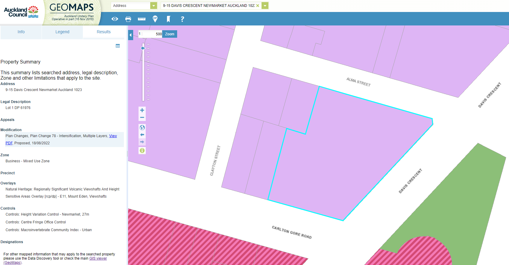
Figure 1 - Auckland Unitary Plan Zoning Map for the Address
On the left hand side of the page the Unitary Plan Map will populate all planning information relevant to the property. In this instance this includes:
- Zoning - Mixed Use Zone.
- Precinct - This does not apply in this example.
- Overlays - Volcanic View Shaft.
- Controls - Newmarket Height Variation Control - 27m, Centre Fringe Office Control and Macroinvertebrate Community Index.
While the focus of this blog is on zoning, this shows that there are other layers that must also be considered in addition to zoning. For example, in this case the Height Variation Control modifies the height limit of the zone, so that rather than having a maximum height of 18m, buildings can be built up to 27m on this site.
By exploring the planning map, property owners can gain insights into the specific zone, rules and overlays that they will have to consider on both their properties and surrounding areas. Understanding the information available on the planning map is essential for making informed decisions about property development.
Exploring Planning Rules for Auckland Properties:
The Unitary Plan introduced by the Auckland Council has had a significant impact on the range of zones now available for development. These zones often aim to balance the need for increased housing supply while preserving the character of established residential neighborhoods.
Intensification is a critical concept that relates to urban zones in Auckland. It involves increasing the density of development in certain areas to accommodate population growth and promote efficient land use. By understanding intensification and its implications, property owners can better navigate planning regulations concerning urban zones.
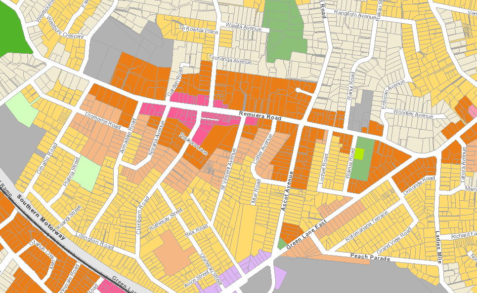
Figure 2 - The Residential Zones
There are four residential zones as shown in the above planning map:
- Single House Zone - Shown as off white
- Mixed Housing Suburban - Shown as light yellow
- Mixed Housing Urban - Shown as orange
- Terrace Housing and Apartment (THAB)- shown as dark orange
These provide a graduated approach to development, with the Single Housing zone providing the least development potential, the Mixed Housing zones providing for up to three dwelling per site with varying height limits, and the THAB zone providing for apartment building and terrace housing typologies.
Applicant should note that the Auckland Council has notified Plan Change 78: Intensification. This intends to significantly change zoning, with most residential areas within the urban area expected to be zoned Mixed Housing Urban. This plan change is not operative so the rules do not currently apply at the time of this blog (July 2024).
Exploring Planning Rules for Auckland Properties:
The Unitary Plan introduced by the Auckland Council has had a significant impact on the range of zones now available for development. These zones often aim to balance the need for increased housing supply while preserving the character of established residential neighbourhoods.
Intensification is a critical concept that relates to urban zones in Auckland. It involves increasing the density of development in certain areas to accommodate population growth and promote efficient land use. By understanding intensification and its implications, property owners can better navigate planning regulations concerning urban zones.
Frequently Asked Questions About Zoning
What are the different house zones in Auckland Council?
The main house zones in Auckland Council include single house zone, mixed housing suburban zone, and mixed housing urban zone and Terrace Housing and Apartment Building Zone.
How do I apply the plan rules to my property?
To apply the plan rules to your property, you can check the Auckland Council website for the zoning applying to your site. You should then refer to Chapter H of the Unitary Plan for the relevant zone and the rules and standards that apply to your property.
What rules apply to single house zone properties?
In the single house zone, specific rules apply to enable low-density residential development with a focus on single houses. Only one principal dwelling is permitted in this zone, however a "minor unit" may also be constructed subject to rules on the size of the minor unit.
What is the significance of an overlay in Auckland's planning rules?
An overlay in Auckland's planning rules indicates additional regulations that apply to certain locations or property types, such as heritage areas or flood zones. In the example used above, the Volcanic View Shaft applying a height restriction above the zoning. In most cases this will be many times higher than the zone height, but in cases where a site is close to a volcanic cone, the overlay may be more restrictive and would limit development heights to 9m. This shows that both zone and overlay rules must be considered together.
How can I find out which zone my property is in?
You can find out which zone your property is in by using the Auckland Council's online zoning maps or contacting the council directly for information. A link to the Unitary Plan map viewer is provided above.
What is a proposed plan change and how does it affect property owners?
A proposed plan change is a potential alteration to the zoning rules or regulations, which can impact property owners by changing what they are allowed to do on their land. The main plan change in process at the moment is PC78. Check out our blog on PC78 for further information on that plan change.
When is a resource consent required for property development?
A resource consent is required when a property development does not comply with the standard rules and regulations of the zone, such as building height or density restrictions or if you do not meet the rules in overlays or general rules that apply Auckland wide. Given the complexity of the Auckland Unitary Plan, it is recommended that you seek the services of a planning consultant. Urban Planning Consultants are always here and ready to help.